At a Glance
- A body was pulled from a landslide that covered a highway.
- Hundreds of people near Estes Park, Colorado, were told to evacuate Tuesday morning.
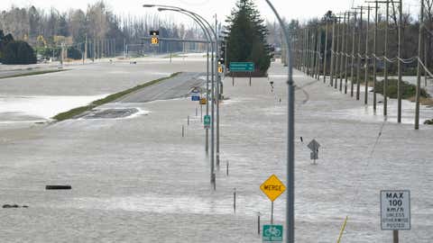
- Roads in Washington and British Columbia were closed due to flooding and landslides.
At least one person is dead after flooding and landslides from heavy rain pounded parts of Washington State and British Columbia.
The body of a woman was pulled from a landslide on Highway 99 near the town of Lillooet, about 117 miles northeast of Vancouver, British Columbia, the Associated Press reported Tuesday evening. The slide was one of several across the region, and was separate from an incident that left hundreds of people stranded overnight on a highway.
Police said rescuers were continuing to search for other possible victims from the landslides.
Seven vehicles were found at the slide site on Highway 99 where the woman's body was discovered.
"It is a significant amount of debris. It makes it very difficult for our search crews," David MacKenzie, Pemberton District Search and Rescue manager, told the AP. "The mud is up to their waist. I can't recall our team being involved in anything like this in the past."
There are reports of at least two other people missing.
Thousands of people were evacuated, major highways closed and widespread power outages reported as the rain, from a storm system known as an atmospheric river, battered the region Sunday night and into Tuesday morning.
The same storm sent high winds over the Rockies and Central Plains that fueled at least one wildfire in northern Colorado.
(MORE: Soggy Northwest Faces More Rain and Mountain Snow)
Here's a look at some of the major impacts.
BC Mayor Says Damage is Heartbreaking
Photos from the British Columbia city of Abbotsford on Tuesday showed homes surrounded by floodwaters.
“It breaks my heart to see what’s going on in our city," Mayor Henry Braun told the AP.
Travelers were told to avoid the area.
Colorado Wildfire Grows Larger
About 150 personnel were working the Kruger Rock Fire, burning southeast of Estes Park, according to an update posted late Tuesday afternoon. More were on the way.
The fire continued to grow to about 115 acres and was 11% contained.
Parts of the Roosevelt National Forest were closed in the area.
Interstate 5 Remained Closed in Bellingham
There was still no word Tuesday evening on when northbound lanes of I-5 in Bellingham would reopen. Crews were working to clear debris from the roadway, according to a tweet from the state Department of Transportation.
Another slide was reported in the area Tuesday afternoon.
Estes Park Fire Forces Evacuations
Residents and businesses in several communities on the southeast side of Estes Park, Colorado, were under a mandatory evacuation order due to a wildfire as of about noon MST.
"It's pretty windy today, so the winds are pushing things around," Deputy Chris Smith, a spokesperson for the Larimer County Sheriff's Office, told weather.com in an early afternoon phone interview.
The National Weather Service said winds were gusting up to 30 mph in the area and were expected to strengthen.
Smith said structures were threatened but there were no reports of damage or injuries so far.
Areas under the order include Little Valley, Hermit Park and Meadowdale, according to emergency alerts sent by Larimer County. Residents in several other areas were being advised to leave.
The blaze, dubbed the Kruger Rock Fire, was reported just before 7 a.m. local time. The cause was still under investigation, Smith said.
The fire had grown to about 100 acres by Tuesday afternoon.
Parts of U.S. Highway 36 were closed due to emergency operations, according to the Colorado State Patrol.
Red Flag Warnings for Fire Conditions
Red flag warnings were in place through at least Tuesday evening from the Dakotas into western Nebraska, parts of Colorado and western Texas and eastern New Mexico.
Gusts up to 60 mph were possible in some areas.
Parts of Interstate 5 Closed
A portion of northbound Interstate 5 in Washington, between Burlington and Bellingham, remained closed as of about 9:30 a.m. PST Tuesday morning due to three landslides that happened Monday. There was no immediate word on when the road might reopen.
Northbound lanes were also closed in Whatcom County north of Bellingham at mile marker 262.
Several other roadways in Whatcom County were also closed.
Washington State Trooper Rocky Oliphant reminded people to be aware of local conditions.
"Road closed signs are there for a reason and that’s your safety," Oliphant tweeted, along with photos of collapsed pavement.
Power Outages
About 45,000 power outages were being reported in Washington, mostly in the northwest part of the state, as of about 11 a.m. PST, according to poweroutage.us.
More than 26,000 outages were being reported in southern British Columbia, where BC Hydro said an aerial damage inspection was completed earlier Tuesday morning.
Evacuations in Washington State, British Columbia
At least 500 people were forced to evacuate Monday in Whatcom County, Washington.
In nearby Clallam County, six adults and four children were rescued from a rooftop by the U.S. Coast Guard in the town of Forks.
Across the border in Canada, all 7,000 people in the town of Merritt were to evacuate, and hundreds of people were rescued after being stranded between mudslides on a highway about 75 miles east of Vancouver, the Associated Press reported.
Driver Melanie Forsythe and her traveling companions were among those who had to be lifted off Highway 7 by helicopter after spending 18 hours stuck on the highway.
"All three of us were kind of hyping each other up, saying it’s going to be good, we’re going to get out of here," Forsythe told the AP. "But then we all had moments like, 'Is this it? Is this the last time we’re going to see our kids?' We were talking to our parents and our families, but it was just a scary situation."
What Is an Atmospheric River?
This was the second time in less than a week the northwest U.S. was hammered by a type of weather pattern called an atmospheric river.
The storm system that tapped into the pipeline of moisture from the atmospheric river is now traveling east with high winds.
Here's how weather.com senior meteorologist Jonathan Erdman described it in a recent article:
"An atmospheric river is a weather feature that is both a necessity and, all too often, a destructive menace particularly for those near the West Coast of the United States.
Put simply, an atmospheric river (AR) is a thin but long plume of moisture in the atmosphere that stretches from the tropics or subtropics into higher latitudes.
If an atmospheric river stalls over land, particularly when that moisture is lifted by mountainous terrain, significant flooding often is the result."

The Weather Company’s primary journalistic mission is to report on breaking weather news, the environment and the importance of science to our lives. This story does not necessarily represent the position of our parent company, IBM.