Western Drought 2020-2022
Climate change is a major contributor to the prolonged and intensifying drought that has impacted the western US since early 2020, as well as the underlying megadrought that has been ongoing since 2000.[1] Rising temperatures due to climate change lead to earlier snowpack melt, increased evaporation from streams and lakes, and increased evapotranspiration from soils and plants. Climate change also increases the risk of seasonal precipitation extremes—including longer and hotter periods with little precipitation that dry out the soil as well as heavier rain and snow events leading to excessive runoff and flooding. Many events have contributed to the severity of the western drought including consecutive dry and warm winters, rapid snowmelt, and record hot summer temperatures.


Climate science at a glance

- Climate change exacerbates drought conditions in the western US through a combination of hot temperatures and, in some areas, a lack of precipitation.
- Climate change has increased the risk of temperature-driven droughts, or ‘hot droughts’ in the Southwest, particularly since 2000.[1]
- Streamflow in the Colorado River is decreasing, driven by warmer temperatures that cause evaporation and early snowmelt.[2][3]
- Higher temperatures sharply increase the risk of megadroughts — dry periods lasting 10 years or more.[4]
- Warmer and drier conditions brought by climate change account for nearly half the severity of the megadrought that has impacted the southwestern US since 2000.[5]
- Nine out of the past 10 years included US droughts costing $1 billion dollars or more. The 2020 Western and Central US drought cost $4.5 billion.
Background
What is a drought?
Drought is about water shortage - the result of complex physical interactions between the land and atmosphere. Droughts can develop quickly - flash droughts are short periods of warm surface temperature characterized by low and rapidly decreasing soil moisture - and they can take shape over much longer periods, as in the case of 'megadroughts', with extreme aridity lasting for decades.
Drought is sometimes defined by the weather or climate conditions that drive below average water supply, as in the case of 'hot droughts', driven by high temperatures that increase the evaporation of surface moisture into the air, or 'meteorological drought', when dry weather patterns lead to below average precipitation. Drought is also defined by the systems impacted by reduced water supply. 'Agricultural drought', for example, occurs when there is insufficient water or soil moisture to meet agricultural demands, and 'hydrological drought' occurs when there's a shortage in water resources, including groundwater and rivers. Ultimately, we care about droughts when there is not enough water to meet needs.
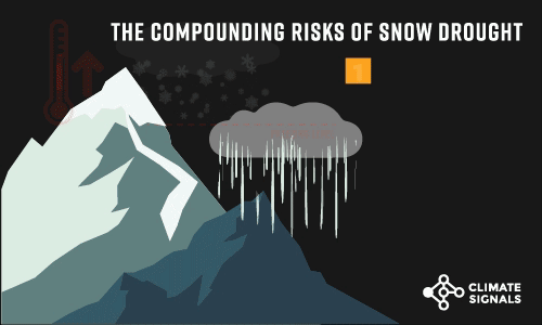
Why is snowpack so important?
How much snowpack is left from the winter to runoff into streams, rivers and reservoirs during the summer is crucial, especially in years when the West is experiencing drought, and climate change is disrupting this important system in several ways. Warmer temperatures mean less snowpack accumulation during colder months, and faster melt as temperatures grow warmer. In addition, unusually dry soils from warmer than normal temperatures and a lack of moisture are absorbing a lot of the water that melts from the snowpack. This means that water isn't making it into rivers and streams, essentially limiting the efficiency of the melting snow.
Colorado's snowpack is the primary source of water for millions of people in Colorado and across the West. In California, the Sierra snowpack supplies about 30 percent of the state's water needs, and the snowpack is an important factor in determining how the state’s water resources are managed.
Are the 2019 and 2020 "nonsoons" (or failed monsoons) a signal of climate change?
The North American Monsoon (NAM) is an important source of annual precipitation for parts of the Southwest from July through September but failed to deliver two years in a row.
In a typical summer, atmospheric high pressure over the southern Rocky Mountains draws moisture in from the Gulf of California and Gulf of Mexico, making July and August the rainiest time of year in Arizona, New Mexico, and the Four Corners region. This rainy period typically provides half of the year’s precipitation in some areas.
However, the 2020 monsoon brought little rainfall due to atmospheric high pressure that was centered farther south than usual. Cities across the Southwest recorded their driest monsoon season on record. Arizona received just 1.51 inches of rainfall on average, compared to the long-term average of 5.37 inches. The 2019 monsoon season was also a bust. Communities in northern Arizona, including Flagstaff and Phantom Ranch at the bottom of the Grand Canyon, experienced record low rainfall. St. George in southern Utah received just traces of rain and most of the Four Corners region didn't fare much better.
Whether and how climate change increases the risk or failed monsoon seasons is an active area of research, but scientists don’t expect a big change to the Southwest’s summer monsoons:
"There is still a lot uncertainty with summer season precipitation because the climate models really struggle to handle all of the small regional nuances that drive regional monsoon precipitation. Largely, they continue to predict little change with maybe some increasing intensity with thunderstorm events and maybe fewer storms overall within the season, but, again, confidence is low."
Mike Crimmins, University of Arizona
When it comes to annual precipitation, however, models project climate change will cause a decrease in the Southwest by mid-century, with emerging evidence suggesting the process is underway.
Climate signals breakdown
Climate signals #1 and #2: Land surface temperature increase and drought risk increase
The average annual surface temperature of the Southwest increased 1.6°F (0.9ºC) between 1901 and 2016, increasing drought risk and taxing water resources. Higher temperatures sharply increase the risk of megadroughts — dry periods lasting 10 years or more — such as the one that has impacted the southwestern US since 2000. Hotter temperatures draw out extra moisture from the soils, intensifying drought conditions.
Observations consistent with climate signals #1 & #2
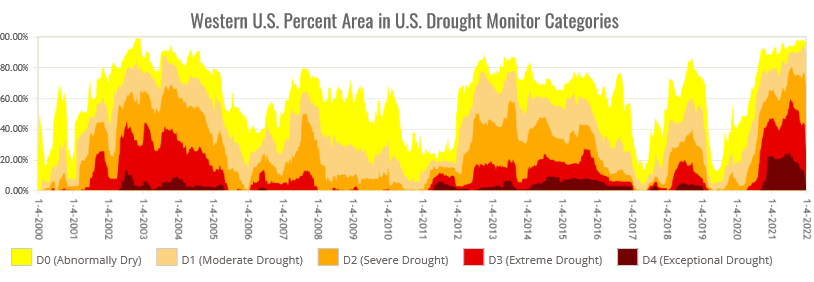
- In the U.S. climate summary for March 2022 issued by the NOAA’s National Center for Environmental Information (NCEI), the agency noted that, “The current multi-year drought across the West is the most extensive and intense drought in the 22-year history of the U.S. Drought Monitor (USDM).” For the first three months of the year (2022), precipitation deficits were nearing or at record levels.
- On August 17, 2021, 26.8% of the continental U.S. was experiencing extreme to exceptional drought. This is the largest extreme to exceptional drought area in the 2000-2021 USDM record.
- The West has experienced a general and persistent increasing trend in temperatures for the last 40 years. Nine of the top ten warmest years have occurred since 2003 and 14 of the warmest 20 years have occurred since 2000.
- The December 7, 2021 maximum of 94.6 percent of the West in moderate to exceptional drought set a record in the 2000-2021 USDM history for the region. On July 20, 2021, 59.5% of the West was covered in extreme to exceptional drought, which was also a USDM record.
- In July 2021, drought conditions in Oregon continued to worsen, becoming the second-worst drought on record in the state.
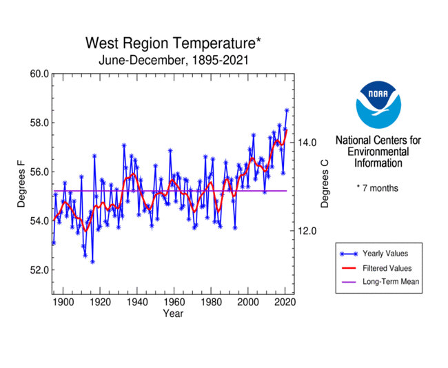
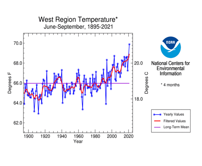
- In 2021, temperatures in the West during June-December, April-September, and June-September each ranked warmest on record in the West for their period.
- In 2020, the West and Southwest recorded their hottest and driest July-September in records dating back to 1895.
- The West ended 2020 with 78.6% of the area covered by moderate to exceptional drought based on the USDM. The most intense areas of extreme to exceptional drought were in the Southwest (Four Corners states) with extreme drought extending across California and Nevada and into the Pacific Northwest and northern Rockies.
- The first week of August 2020, the USDM assessment designated all of Colorado, and much of the West, in some stage of drought. It’s the fourth time in two decades — following 2002, 2006 and 2012 — that all of Colorado was designated as abnormally dry or in drought.
Climate signals #3 and #4: Snowpack melting earlier and/or faster and precipitation falls as rain instead of snow
The mountainous western US is heavily dependent on a good winter snowpack.
Temperature directly influences mountain snowpack, which provides natural storage of precipitation during cold winter months, until temperatures warm and it melts to provide water in the form of runoff. Over the past few decades, warming temperatures have been linked to changes in the percentage of precipitation falling as rain or snow, and snow melt anomalies showing a trend towards earlier and faster stream flow.[6][7]
Reduced spring stream flow increases wildfire risks. Dried out vegetation is a perfect fuel for fires, so when fires start, they can burn more intensely and over larger areas.
Observations consistent with climate signals #3 & #4
- Much of the West (California and Nevada) and Southwest (Arizona, Utah, Colorado, and New Mexico) endured two consecutive warm winters in 2019-2020 and 2020-2021.
- In early 2020, snowpack (the amount of water accumulated in the snow) peaked well below average and melted too fast in the Cascades and Sierra Nevadas. In the Rockies, snowpack peaked near average but warm temperatures brought unusually fast melt.
- Lakes Powell and Mead (both connected to the Colorado River Basin that supplies water for millions throughout the West) had significant deficits by late spring 2020.
- By January 2021, water levels in Lake Powell, the river’s second-largest reservoir, dropped to unprecedented depths, triggering a drought contingency plan for the first time for the Upper Basin states of Colorado, Wyoming, Utah and New Mexico.
- Even after the powerful late spring snowstorm in March 2021 brought much needed precipitation to Colorado, snowpack in the headwaters of the Colorado River is running below average.
- On March 23, 2021, California's statewide snowpack was at 63 percent of the historical average for April 1.
- By mid-June, nearly all of the SNOTEL sites in the western region reported less than 50 percent of their normal snow-to-water equivalent amounts. Many were at or near 0%.
Climate signal #5: Weather whiplash
Human-caused climate change has increased the extremes between periods of drought and periods of high precipitation. The chance of going from major drought to high precipitation events more suddenly than normal is increasing.
Observations consistent with climate signal #5
- Sacramento experienced its wettest day on record on October 24, shortly after experiencing its longest consecutive dry spell on record. The record-breaking precipitation only slightly reduced California's drought designation and was followed by much drier and warmer conditions.

Rose Andreatta
Rose Andreatta is the director of the Climate Signals project and has over a decade of experience translating scientific information into usable formats for a variety of audiences. Rose earned her Master’s of Public Administration in Environmental Science and Policy at Columbia University and holds a Certificate of Achievement in Weather Forecasting from Pennsylvania State University.
Related Content


