Communities in western Canada who were forced to flee their homes this summer by wildfires and extreme heat are once again under evacuation orders after overwhelming floods across the region.
The heavy rainfall and pounding storms are also taking a toll on the US Pacific north-west, where flooding and mudslides in Washington state have also forced evacuations and school closures.
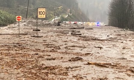
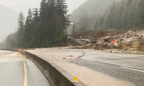
Helicopters were dispatched on Monday to Highway 7, more than 100 kilometres (62 miles) east of Vancouver, to rescue about 275 people, including 50 children, who had been stranded on the road since it was blocked by a mudslide late on Sunday.
Footage from the area shows stranded travelers heading toward a yellow emergency helicopter during the rescue operation. The surrounding landscape is littered with debris from a landslide blocking access to the highway.
“I definitely heard people screaming for help,” Adam Wuisman, who was driving the section of the highway when a landslide hit, told CBC News. “It’s kind of helpless to feel like you’re between a very vulnerable mountainside on one side and the Fraser River on the other side. And there’s really nothing you can do about it, but hope nothing comes down on top of you.”

Images of surging rivers, mudslides, flooded cities and destroyed highways circulated on social media as officials scrambled to assess the full extent of the damage, warning residents the situation could deteriorate further as winds picked up throughout the day.
According to Environment Canada, 225 millimetres of rain fell on the community of Hope since the storm began Saturday and 180 millimetres had fallen around Agassiz and Chilliwack in the eastern part of the Fraser Valley.
After two bridges and its water treatment facility were overwhelmed by flood waters, the city of Merritt issued an evacuation order to all residents, warning that “continued habitation of the community without sanitary services presents risk of mass sewage back-up and personal health risk”.
Merritt last issued evacuation orders this summer after the wildfire that destroyed the village of Lytton came dangerously close to the city.
Since June, the province has experienced a record-setting “heat dome”, huge wildfires that destroyed two towns and choked the air for weeks, extreme events that experts say were worsened by the climate crisis. Last week, Vancouver, British Columbia’s largest city, was briefly placed under tornado watch, a rare event for the region.
In Washington state, the National Weather Service warned that winds nearing hurricane strength were possible in the region, which has seen nearly ceaseless rain for about a week. A wind gust of 58mph (93km/h) was reported on Monday at Sea-Tac international airport in Seattle.
More than 158,0000 customers were without power in western Washington at one point Monday, the Seattle Times reported.
Parts of the region have seen more than 6in (15cm) of rain in the past several days. Less than halfway into the month it is already the third wettest November that Seattle has seen in more than a century, according to the Washington Post, with rainfall records likely to be broken.
A state of emergency was declared over the weekend for the town of Hamilton, about 80 miles (129km) north-east of Seattle, and residents were urged to evacuate as soon as possible, the Skagit Valley Herald reported.
As the water was making its way down the Skagit River, people were warned to expect flooding in the cities of Sedro-Woolley, Burlington and Mount Vernon. Just south of the Canadian border in Sumas, Washington, officials said city hall was flooded and that the flooding event was the worst in decades.
Nicole Postma, who owns a coffee stand in Sumas and is president of the Sumas Chamber of Commerce, told the Bellingham Herald on Monday that people are nervous.
“We knew that the flood was imminent, but had no idea it would be like this,” she said.
The Associated Press contributed reporting


